Chantal Downgraded to Tropical Depression: What Americans Should Know About Its Path, Risks, and Hurricane Preparedness in 2025
From wind damage to rip currents, here’s your full guide to the impacts of Chantal and how to prepare for the rest of the hurricane season.
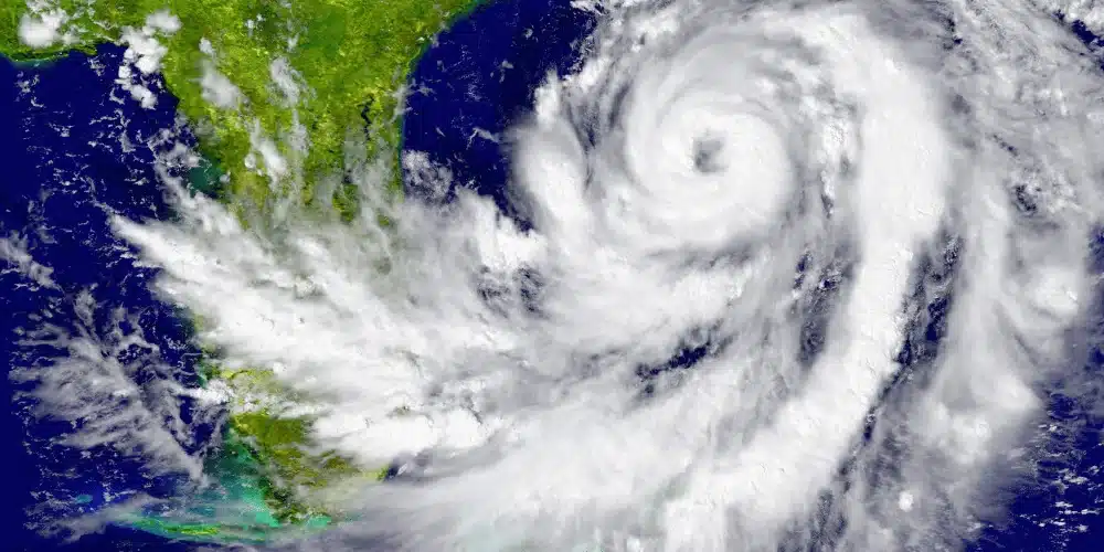
Tropical Storm Chantal, once a fast-developing threat in the Atlantic basin, has now weakened into a tropical depression as it moved inland across the Carolinas.
Though its wind strength diminished considerably by the morning of Sunday, July 6, Chantal still brought with it heavy rain, the risk of flash floods, and hazardous rip currents.
With hurricane season entering its active phase, Chantal’s path is a timely reminder that even a downgraded storm can carry serious consequences.
In this in-depth guide, we will walk through everything you need to know about Chantal’s impact, what areas were hit hardest, how tropical systems form, and — most importantly — how to prepare for the ongoing 2025 hurricane season.
🌪️ What Happened to Tropical Storm Chantal?
Chantal became the third named storm of the 2025 Atlantic hurricane season after forming and intensifying over warm ocean waters on Saturday, July 5.
It made landfall near Litchfield Beach, South Carolina around 4 a.m. local time on Sunday, with sustained winds nearing 40 mph.
By midmorning, the National Hurricane Center (NHC) reported that wind speeds had dropped to about 35 mph, reclassifying Chantal as a tropical depression.
Despite this weakening, Chantal continued to carry threats for large swaths of the southeastern U.S., particularly in South Carolina and eastern North Carolina.
The system was moving north at about 9 mph and was forecasted to push through eastern North Carolina by Sunday night.
📍 Areas Most Affected by Chantal’s Impact
While Chantal’s wind speeds did not meet hurricane strength, the system still delivered powerful environmental effects:
- Rainfall Totals:
- Forecasts predicted 2 to 4 inches of rain, with some areas receiving up to 6 inches. This was enough to prompt flash flood warnings in urban and low-lying areas.
- Storm Surge and Tides:
- The NHC cautioned that the combination of storm surge and high tides could cause coastal flooding. Areas typically dry could see water advancing from the shoreline, particularly during high tide cycles.
- Surf and Rip Currents:
- Dangerous ocean conditions extended far beyond the storm’s center. Life-threatening rip currents and strong surf were reported along the coasts from the Carolinas down to northern Florida, including cities like Savannah, Georgia, and Jacksonville, Florida.
- Wind Damage Risk:
- Although the storm’s center stayed offshore, gusty winds caused localized tree damage, power outages, and minor structural impacts near landfall. According to AccuWeather Senior Meteorologist Tyler Roy, the strongest winds typically occur east of a tropical system’s center — meaning coastal communities remained at risk even as the core weakened.
🌊 The Science Behind Hurricane Formation
Chantal’s development is a textbook example of how tropical storms form in the Atlantic.
Here’s a simplified breakdown:
- Warm Water is the Fuel:
- Hurricanes originate above waters that are at least 80°F. This warmth causes evaporation and generates rising columns of moist air.
- Thunderstorm Clusters Form:
- These moisture-laden clouds merge into a tropical wave or tropical disturbance. If atmospheric conditions are right (low wind shear, high humidity), the system can strengthen.
- Tropical Depression Phase:
- Once a closed circulation forms and sustained winds reach less than 39 mph, it’s classified as a tropical depression.
- Becoming a Tropical Storm or Hurricane:
- If sustained winds reach 39 mph, the system gets a name. At 74 mph, it’s officially a hurricane.
While Chantal peaked as a tropical storm, other systems in the 2025 season may grow much stronger — especially as we enter peak hurricane months from mid-August to mid-October.
🌀 The 2025 Hurricane Season So Far
Chantal is the third storm of this year’s hurricane season, which officially began on June 1 and runs through November 30.
Here’s a quick timeline of the named storms so far:
- Andrea: The first named storm in early June. Brought moderate rain and minimal coastal impacts.
- Barry: A short-lived system with limited land interaction.
- Chantal: The first storm of the season to make significant U.S. landfall.
Meteorologists are closely monitoring several other tropical waves forming off the coast of Africa, and forecasters at NOAA have predicted a slightly above-average season in terms of storm activity.
⚠️ How to Prepare for Hurricanes in 2025
Whether you live on the coast or several miles inland, hurricane preparedness is not optional.
The following steps, recommended by NOAA, can help protect your life, property, and peace of mind.
🧳 1. Build a Disaster Kit
Stock your home or evacuation bag with essentials:
- Water (1 gallon per person per day for 3–7 days)
- Non-perishable food
- Flashlights and batteries
- First aid supplies
- Medications
- Backup chargers for electronics
- Copies of personal documents
🚗 2. Create an Evacuation Plan
Map out two evacuation routes from your home and establish a plan for pets.
Know where your nearest shelter is and whether it accepts animals or medical needs.
📑 3. Check Your Insurance Coverage
Homeowners and renters insurance does not provide coverage for flood damage.
You must purchase separate flood insurance, and there’s often a 30-day waiting period, so don’t delay.
Take photos of your home and valuables now, and store them in a safe location — this documentation is critical for claims.
👨👩👧 4. Set Up a Family Communication Plan
Designate an out-of-town contact and decide how your family will connect if power and cell towers go down. Print out emergency contact info and store it in your wallet and car.
🏡 5. Strengthen Your Property
Now is the time to:
- Trim tree branches near your home.
- Seal any cracks and gaps in walls or foundations.
- Install storm shutters or impact glass.
- Anchor outdoor furniture and grills.
📍 Lessons from Chantal: Take Every Storm Seriously
Chantal may not have caused the level of destruction often associated with hurricanes, but it served as a powerful reminder of how quickly tropical systems can impact large regions — even without hurricane-force winds.
From flooded coastal roads to disrupted beach vacations and downed power lines, the storm’s effects stretched beyond its weakened core.
And as rip currents continue into the following week, swimmers and boaters along the Southeast U.S. coastline are advised to exercise extreme caution.
🧠 Final Thoughts: Why Early Action Matters
Each hurricane season brings uncertainty, but it also brings an opportunity for early preparation. Chantal was mild compared to what may follow later in 2025.
Whether you’re a resident of the Gulf Coast, the Carolinas, or even further inland, having a plan is your best defense.
Don’t wait for the next storm to make headlines.
Review your evacuation routes, check your coverage, talk with your family, and act now — while you still have the chance to prepare safely and calmly.


